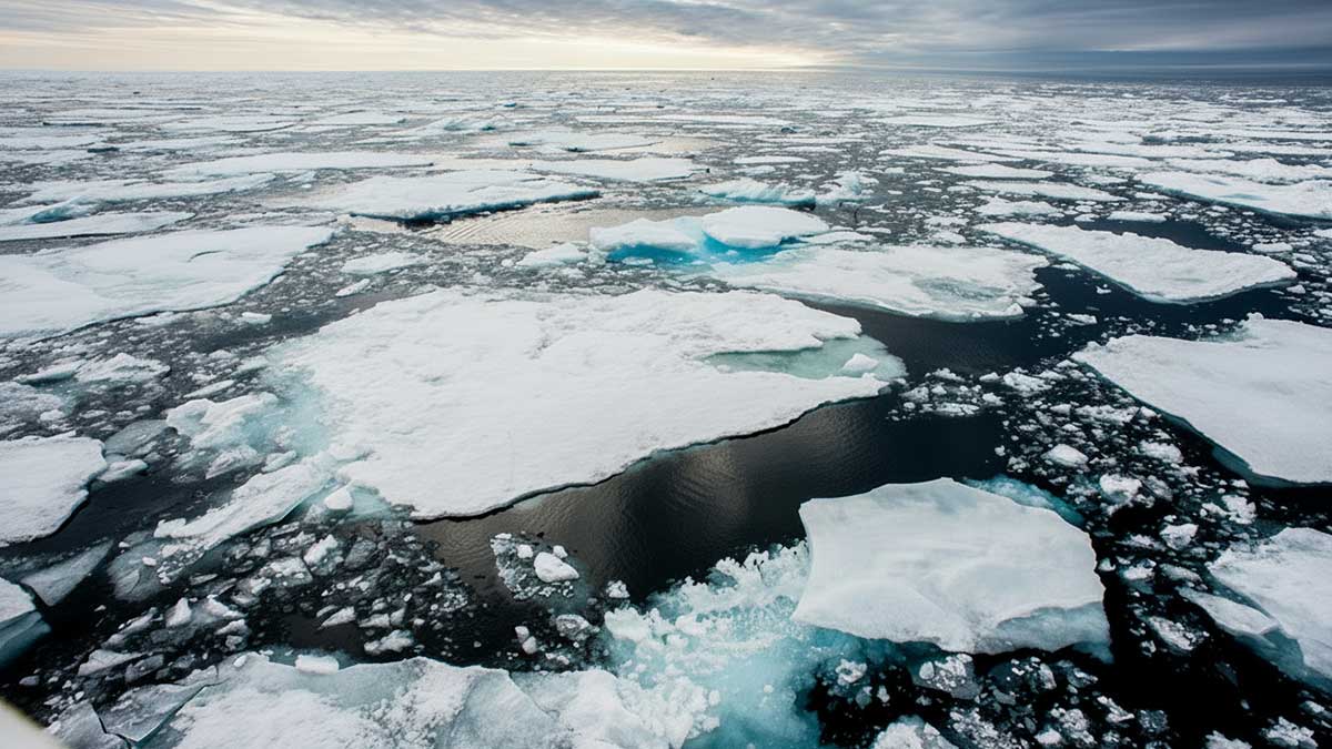
In March 2026, the Arctic’s winter sea ice reached one of the lowest levels ever recorded, at 5.52 million square miles, about 10% below the 30-year average. This was 10,000 square miles less than the 5.53 million square miles measured in 2025. The Arctic winter sea ice covered 5.56 million square miles in 2017 and 5.79 million square miles in 2020, and has been declining since then.
Less white ice means more dark ocean water, and dark water absorbs heat rather than reflecting it, speeding up warming, or so we are told. Yet, any helmsman will attest that the ocean is never truly black, except on a moonless night. Light reflects off the sea as brightly as the sky. A cloud-covered sky lowers the reflection, turning the ocean gunmetal gray.
Science is a cycle of observing, questioning, recording, and sharing. Imagine practicing science with a pair of pint glasses on a sunny day. Fill one glass with cold black coffee and the other with cold white milk. Place a thermometer in each and observe what happens over time.
Both the pint of coffee and the pint of milk will reach the same temperature as the air. The heating occurs through conduction, with the glass in contact with the air. Unlike a black car seat, water molecules are free to move. The chaotic motion of warming water molecules makes it impossible to heat water in a glass or coffee in a mug above room temperature with a hair dryer. Dark waters are not warmed by sunlight and so are not responsible for melting sea ice. Waters are warmed by contact with warmer surfaces, like when a coffee pot is placed on the stove.
The Arctic Ocean connects to the Atlantic Ocean via the Greenland Sea, which is part of the Atlantic. The Svalbard Archipelago is on the threshold between the two oceans. To the east of Svalbard is the Barents Sea. Covering about 540,000 square miles, the Barents Sea is north of Norway and Russia and west of Franz Josef Land. On the continental shelf, it is relatively shallow, with an average depth of about 750 feet. The average depth of the Arctic Sea to the North is about 3,900 feet.
The Arctic isn’t melting uniformly like a spring pond. Melting starts with warm Atlantic Gulf Stream water. Nearly all the Arctic Sea ice loss, totaling 525,000 square miles, happens in the Barents Sea, a part of the Arctic Ocean. This occurs because of the Coriolis Effect, a phenomenon caused by the Earth’s eastward rotation. The equator moves faster through space than the North Pole. As a result, water flowing north curves to the right. When it enters the Arctic, warm Atlantic water flows directly into the Barents Sea.
In April 1810, the whaler William Scoresby lowered a ten-gallon wooden cask made of fir into the deep after overwintering in the Greenland Sea west of Svalbard. This design was by Joseph Banks, the scientist on Cook’s expedition. Fir was the preferred wood because it is a softwood that insulates better than harder woods. Scoresby was surprised to find that the Gulf Stream water at 100 to 200 fathoms deep was six to eight degrees warmer than the Arctic water above. He didn’t believe it at first and modified the cask to record the temperature more quickly. However, the results were consistent. The Gulf Stream was flowing into the Arctic Ocean, separated from the sea ice by a layer of less salty, denser Arctic water.
Besides discovering changes occurring in the Greenland Sea, Scoresby observed, “changes of climate to a certain extent, have occurred, …, considered as the effects of human industry, in draining marshes and lakes, felling woods, and cultivating the earth” (Scoresby 1821, page 263).
Over time, the loss of vegetation and soils, replaced by hard surfaces that have become heat islands, has resulted in more and warmer stormwater runoff into the Atlantic. This happened without a change in annual rainfall. More water strengthens the Gulf Stream, and as temperatures rise, the expanded water has moved closer to the surface in the Arctic.
In 2007, the Gulf Stream surfaced in Svalbard, and warm water began melting glaciers on land.
During the winter of 2010-2011, the Gulf Stream was observed to have a more pronounced meander onto the Continental Shelf closer to Rhode Island than ever before. This indicates a need for a strengthened Gulf Stream to dissipate more energy.
The Gulf Stream flows past New Jersey at 30 to 40 Sverdrups, or 30 to 40 million cubic meters per second, with a seasonal variation of 5-15%. Maximum flow usually occurs in late summer to early fall. It gathers water as it barrels northward. The Gulf Stream transports more than 100 Sverdrups east of the Grand Banks off Newfoundland,
Only 2-3% of the total Gulf Stream flow is carried by the Norway Current into the Barents Sea, but it punches far above its weight in terms of climate impact in the Arctic Ocean.
Atlantification is the process by which warm Atlantic water melts Arctic sea ice. This leads to thinner winter sea ice that melts faster in summer. NASA imagery shows the Siberian coast from Norway to Alaska opening nearly simultaneously. The counter-clockwise gyre created by Atlantic water entering the Arctic pushes ice against Canada and Northern Greenland.
Rounding Greenland, the Arctic Ocean current flows south along Greenland and into the Denmark Strait between Iceland and Greenland. Here, the cold, nutrient-rich Arctic water meets warm, nutrient-poor Atlantic water and plunges 11,500 feet down. The Earth’s largest waterfall, three times taller than Angel Falls, is underwater.
The East Greenland Current will become the Labrador Current after rounding Greenland, carrying oxygen-rich and nutrient-rich waters into the Atlantic. The Grand Banks off Newfoundland will force Arctic waters to mix with warm, salty water, creating arguably the world’s most productive fishing region.
The Northeast Passage, the Arctic Ocean sea route from the Atlantic along the coast of Siberia to the Pacific, opened in the early 2000s. In 2007, the Northwest Passage through the Canadian Arctic Archipelago opened to shipping. The close timing of the two passages’ openings was a surprise, given our understanding of oceanography. However, solar radiation off the granites and gneiss (igneous and metamorphic) rocks of the Canadian Shield made the difference for a region where warm Atlantic water could not reach.
We need to reduce surface runoff by increasing vegetation cover and soil depth to help water stay on the land where it falls, while restoring the Arctic’s winter sea ice and cooling the climate. Additionally, we should naturally lessen the heat island effects of our structures by providing more shade and transpiration cooling from plants. Slowing down water flow during times of abundance to ensure it is available where and when nature needs it will lower seasonal ocean warming.
There are immediate benefits to having more water on land, such as more greenery, less warming, and decreased ocean swelling. The advantages for land, water, and sky are vast and difficult to fully understand. Still, the benefits of restoring Arctic sea ice are clear and serve as a clarion call for responsible local actions by all property owners, no matter where they are in the watershed we call Earth.
About the Author
Dr. Rob Moir is a nationally recognized and award-winning environmentalist. He is the president and executive director of the Ocean River Institute, a nonprofit based in Cambridge, MA, that provides expertise, services, resources, and information not readily available locally to support the efforts of environmental organizations. Please visit www.oceanriver.org for more information.
The post Guest Idea: Stormwater Runoff into the Atlantic and the Atlantification of the Arctic appeared first on Earth911.