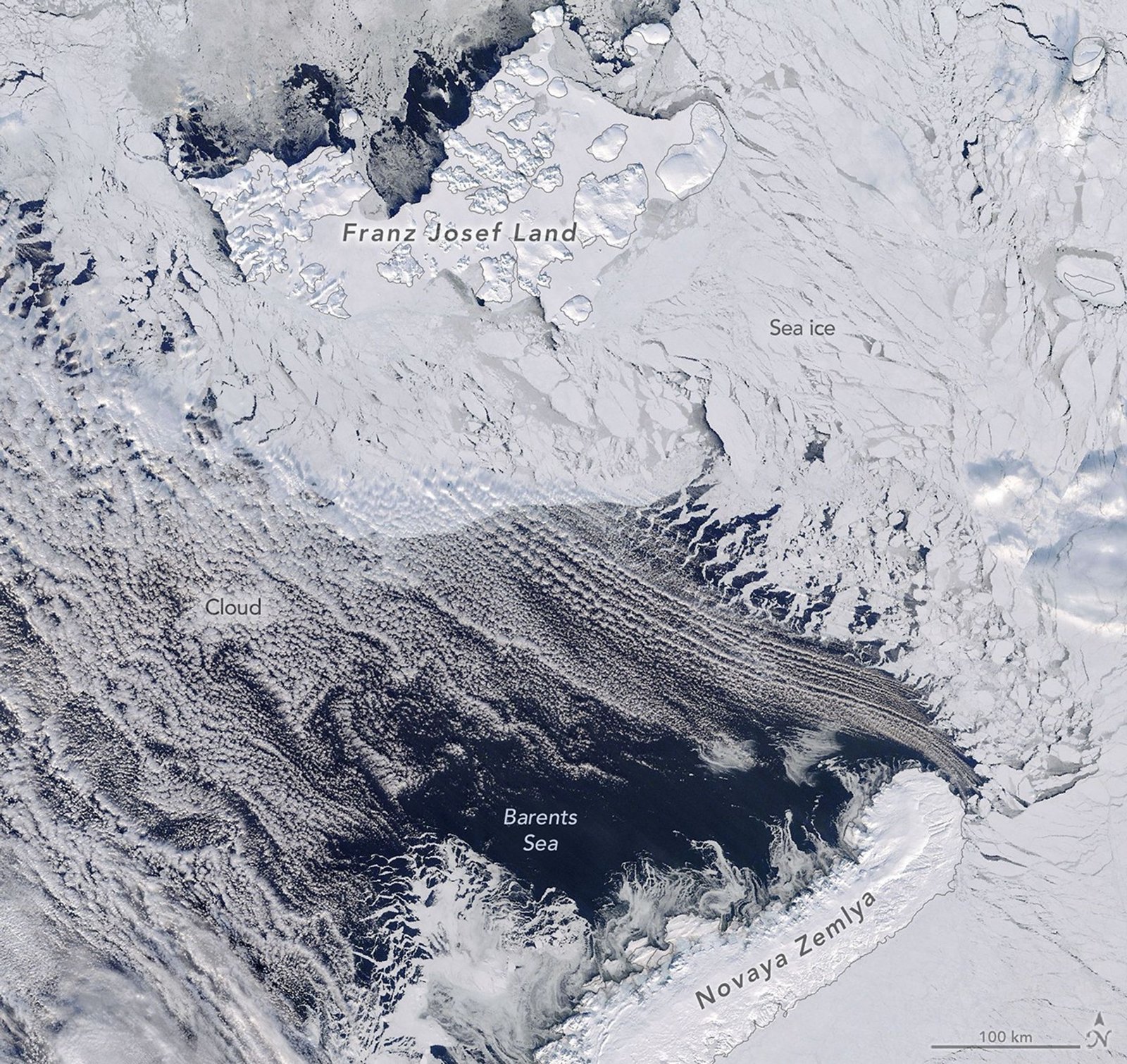
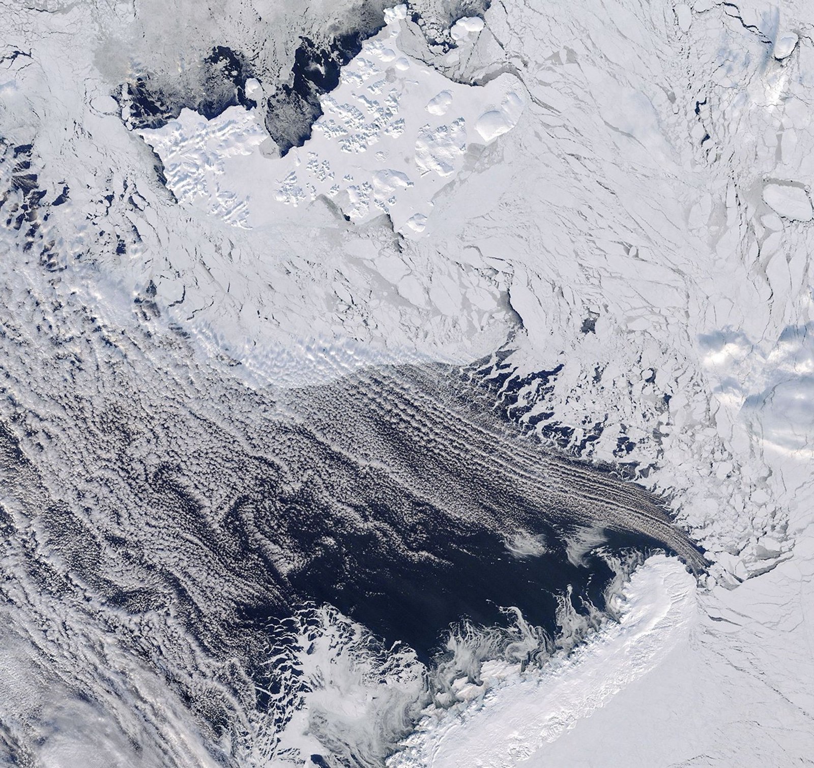
At the top of the planet, the cap of sea ice across Arctic waters grows and shrinks with the seasons, usually reaching its annual maximum extent in March. In 2026, this peak occurred on March 15, when the extent reached 14.29 million square kilometers, matching the lowest maximum observed since satellite monitoring began in 1979. One of the key areas contributing to the low maximum this year was the Barents Sea.
The Barents Sea lies at the periphery of the Arctic Ocean, bordered to the northwest by the Norwegian archipelago of Svalbard, and to the northeast and east by the Russian islands of Franz Josef Land and Novaya Zemlya, respectively. It is one of more than a dozen subregions—including the Central Arctic Ocean and nearby seas, bays, and waterways—across which scientists use remote sensing to track sea ice. The region is important for fisheries, shipping routes, and scientific research.
On March 17, 2026, the Terra satellite captured this image of the northern Barents Sea. Near Franz Josef Land, broken sea ice drifted near areas of open water closer to Novaya Zemlya. The region is often cloudy, as it was that day, but most clouds were thin enough to reveal the sea ice and water below.
In addition to the low extent, data from NASA’s ICESat-2 satellite indicate that Barents sea ice in mid-March 2026 was also very thin, according to Nathan Kurtz, chief of the Cryospheric Sciences Laboratory at NASA’s Goddard Space Flight Center.
Previous years, such as 2021 and 2025, also saw especially thin ice around the time of the maximum. “What was striking this year, however, was that the ice was also completely melted away in more of the Barents Sea, in addition to areas of thinning spreading northward,” Kurtz said.
On the opposite side of the Arctic, the Sea of Okhotsk also contributed to the low total sea ice extent across the Arctic in March 2026. But the factors driving the losses differ between the two regions.
In the Barents, studies have shown that the main driver is large-scale atmospheric circulation, with winds channeling warm, humid air from the North Atlantic straight into the area, accelerating melt. These winds can be influenced by tropical weather thousands of miles away. Disturbances originating over the Maritime Continent near Indonesia can “send ripples through the atmosphere that reach the Arctic within one to two weeks,” Kurtz said.
In contrast, the Sea of Okhotsk mostly has thin, seasonal ice that changes thickness from year to year. Local winds play a big role, sometimes pushing the ice together to create thicker, ridged areas, and other times spreading it out, making it thinner. Because of this, the ice loss there is mainly driven by local weather, unlike in the Barents Sea, where distant atmospheric forces have a greater impact.
NASA Earth Observatory image by Michala Garrison, using MODIS data from NASA EOSDIS LANCE and GIBS/Worldview. Story by Kathryn Hansen.
References & Resources
- NASA (2026, March 26) Arctic Winter Sea Ice Ties Record Low, NASA, NSIDC Scientists Find. Accessed April 2, 2026.
- National Snow and Ice Data Center (2026) MASIE-NH Daily Image Viewer. Accessed April 2, 2026.
- National Snow and Ice Data Center (2026, March 25) Arctic sea ice record low maximum strikes again. Accessed April 2, 2026.
- Nihashi, S. et al. (2018) Estimation of sea-ice thickness and volume in the Sea of Okhotsk based on ICESat data. Annals of Glaciology, 59 (76pt2), 101-111
- NOAA (2025) Regional Sea Ice. Accessed April 2, 2026.
- Yu Feng Siew, P. et al. (2023) Physical Links from Atmospheric Circulation Patterns to Barents–Kara Sea Ice Variability from Synoptic to Seasonal Timescales in the Cold Season. Journal of Climate, 36, 8027–8040.
- Zheng, C. et al. (2022) Turbulent Heat Flux, Downward Longwave Radiation, and Large-Scale Atmospheric Circulation Associated with Wintertime Barents–Kara Sea Extreme Sea Ice Loss Events. Journal of Climate, 35, 3747–3765.
You may also be interested in:
Stay up-to-date with the latest content from NASA as we explore the universe and discover more about our home planet.
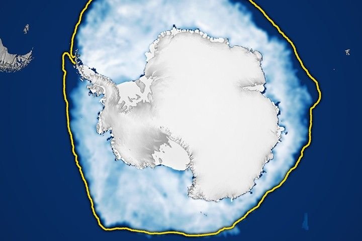
Sea ice around the southernmost continent hit one of its lowest seasonal highs since the start of the satellite record.
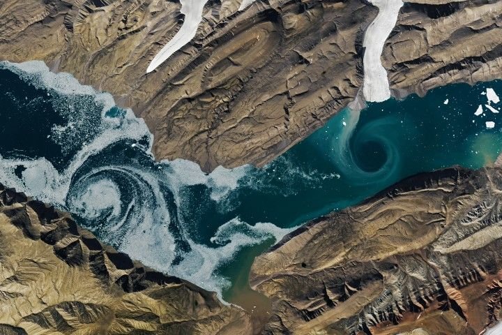
During the 2022 summer melt season, sediment plumes and fractured sea ice traced swirling eddies in a branch of the…

A network of meltwater lakes and drainage channels made an Antarctic ice shelf known for its blue ice areas even…