How Big Is Australia Visualizing How Many Countries Fit Inside
See visuals like this from many other data creators on our Voronoi app. Download it for free on iOS or Android and discover incredible data-driven charts from a variety of trusted sources.
Key Takeaways
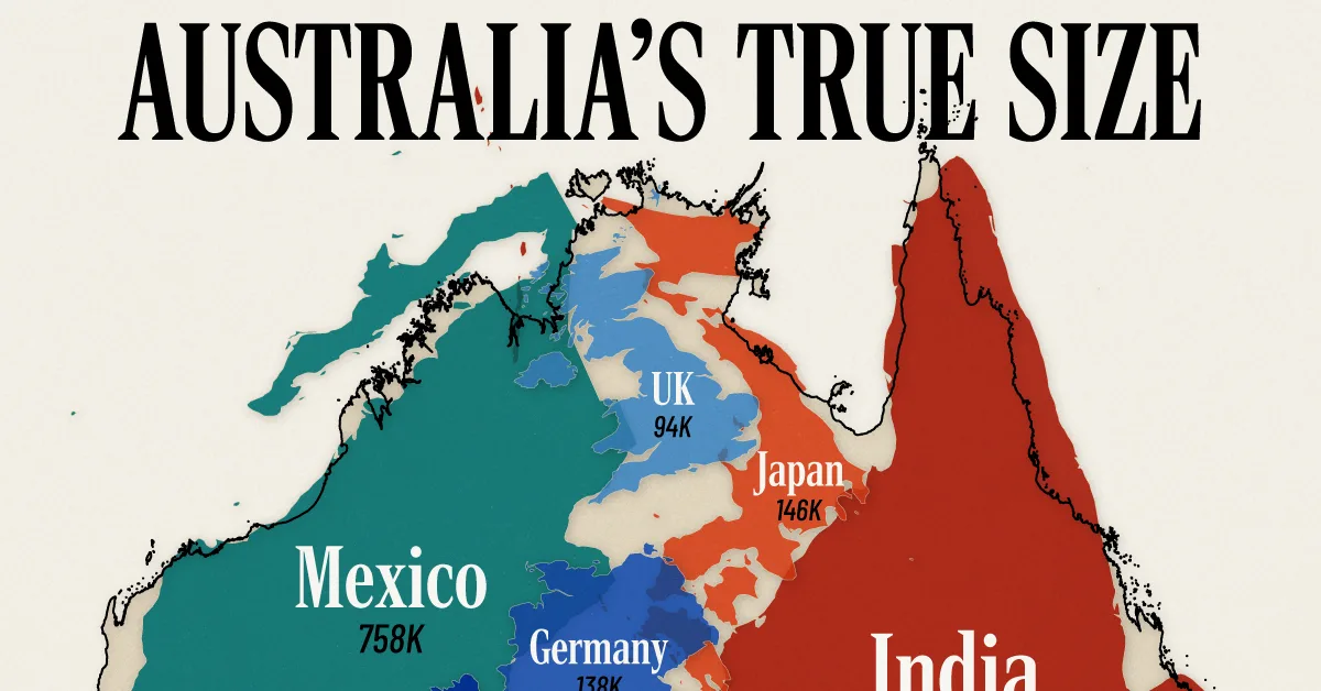
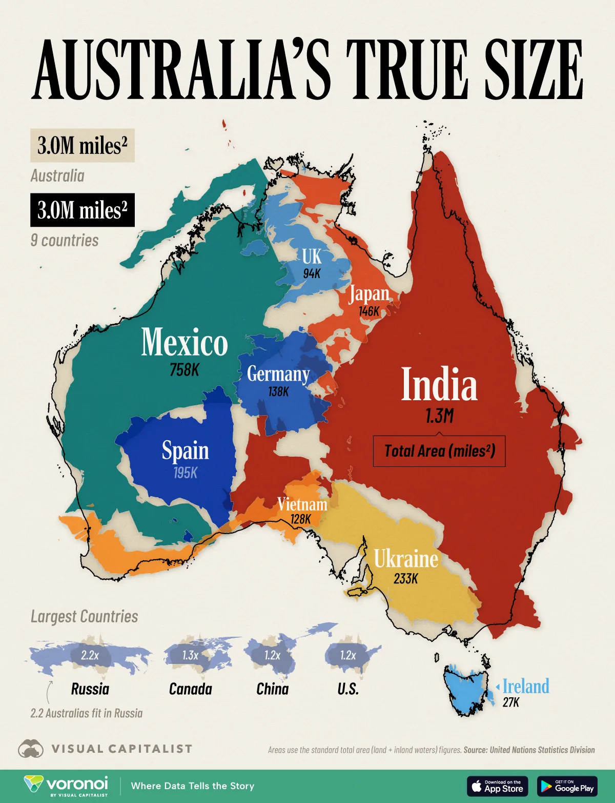
- Australia is the 6th-largest country in the world at nearly 3.0 million mi² (7.7 million km²), and it’s large enough to fit nine other countries, including 7th-ranked India.
- Around 40% of Australia is uninhabitable due to harsh desert conditions in the interior.
- Most of its 27 million residents live along the coast.
Australia ranks 54th by population, 14th by gross domestic product…and sixth by size?
The infographic below puts its staggering scale in context by showing how many familiar nations could sit comfortably inside its outline.
The data for this visualization comes from UN Statistics Division, using total area estimates.
Australia’s True Size Revealed
Covering nearly 3.0 million square miles (7.73 million km²), Australia is the sixth-largest country, sitting just behind Brazil.
| Country | Area (mi²) | Area (km²) | Population (2025) |
|---|---|---|---|
 Australia Australia |
2,988,900 | 7,741,221 | 27,740,000 |
 India India |
1,269,219 | 3,287,265 | 1,460,000,000 |
 Mexico Mexico |
758,449 | 1,964,375 | 133,370,000 |
 Spain Spain |
195,120 | 505,359 | 49,720,000 |
 Japan Japan |
145,914 | 377,916 | 123,290,000 |
 Germany Germany |
138,063 | 357,582 | 83,600,000 |
 UK UK |
94,354 | 244,376 | 69,870,000 |
 Ukraine Ukraine |
233,030 | 603,545 | 32,860,000 |
 Vietnam Vietnam |
127,930 | 331,337 | 102,160,000 |
 Ireland Ireland |
27,133 | 70,274 | 5,490,000 |
 9 Countries 9 Countries |
2,989,212 | 7,742,029 | 2,054,875,000 |
Note: Population data sourced from the International Monetary Fund.
Its landmass is roughly equivalent to the combined size of nine other countries, including 7th-ranked India.
For an American perspective, it’s the size of the contiguous U.S. west of the Mississippi River.
Humans often underestimate continental scale when viewing Mercator maps, so stacking countries gives a more intuitive sense of magnitude.
 Related: For more on the Mercator projection, check out: The Problem With Our Maps.
Yet with only 27 million residents, Australia’s average population density is nine people per square mile.
The average population density of the combined nine countries is 687 people per square mile.
Why So Much of Australia Is Empty
The emptiness stems largely from the notorious Outback.
Roughly two-fifths of the continent is classified as arid or semi-arid desert, encompassing the Simpson, Tanami, and Great Victoria deserts.
Summer highs above 110°F (43°C) and some of the lowest rainfall on Earth make permanent settlement costly and risky.
Consequently, more than 85% of Australians cluster in coastal metro areas such as Sydney, Melbourne, Perth, and Brisbane.
Learn More on the Voronoi App 
If you enjoyed today’s post, check out Visualizing Africa’s True Size on Voronoi, the new app from Visual Capitalist.
- Source: https://www.visualcapitalist.com/how-big-is-australia-visualizing-how-many-countries-fit-inside/