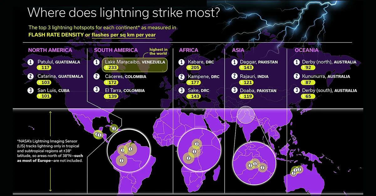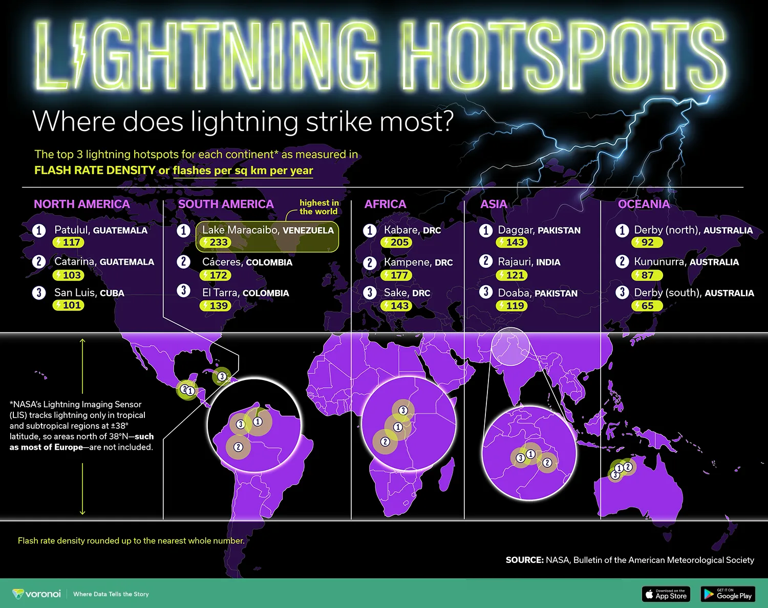
Mapped: Lightning Strike Hotspots Around the World
This was originally posted on our Voronoi app. Download the app for free on iOS or Android and discover incredible data-driven charts from a variety of trusted sources.
Key Takeaways
- Lake Maracaibo in Venezuela records the highest lightning flash rate density on Earth.
- About 70% of lightning occurs on land in the Tropics, where the majority of thunderstorms occur.
- NASA’s data excludes much of Europe and higher latitudes due to satellite coverage limits.
Lightning is a global phenomenon, but it does not strike evenly across the planet. Some regions experience lightning activity at rates that are dozens of times higher than the global average, driven by geography, climate, and atmospheric conditions.
The visualization above, created by Julie Peasley, maps the top lightning hotspots on each continent using data from NASA’s Lightning Imaging Sensor (LIS). It highlights where lightning strikes most frequently based on flash rate density, measured as the number of flashes per square kilometer per year.
Here is the data showing the leading lightning hotspots by region, based on NASA LIS measurements:
| Continent | Location | Flash Rate Density |
|---|---|---|
| North America | Patulul, Guatemala | 117 |
| Catarina, Guatemala | 103 | |
| San Luis, Cuba | 101 | |
| South America | Lake Maracaibo, Venezuela | 233 |
| Cáceres, Colombia | 172 | |
| El Tarra, Colombia | 139 | |
| Africa | Kabare, DRC | 205 |
| Kampene, DRC | 177 | |
| Sake, DRC | 143 | |
| Asia | Daggar, Pakistan | 143 |
| Rajauri, India | 121 | |
| Doaba, Pakistan | 119 | |
| Oceania | Derby, Australia | 92 |
| Kununurra, Australia | 87 | |
| Derby, Australia | 65 |
Across continents, the pattern is clear. Northern South America and central Africa dominate the rankings, with flash rates that far exceed those seen elsewhere. Lake Maracaibo in Venezuela stands out as the most lightning-prone location on Earth, earning its reputation as the planet’s lightning capital.
Why Do These Lightning Hotspots Exist?
Lightning hotspots tend to form where warm, moist air rises consistently and collides with cooler air aloft. In places like Lake Maracaibo, surrounding mountains help trap heat and moisture, creating ideal conditions for frequent and intense thunderstorms.
Similar dynamics occur in parts of the Democratic Republic of the Congo and northern India, where strong solar heating and seasonal weather patterns fuel powerful convective storms. These regions see lightning activity on a near-daily basis during peak seasons.
How NASA Measures Lightning From Space
The Lightning Imaging Sensor detects lightning flashes by capturing brief bursts of light from storms as viewed from orbit. According to NASA, LIS data has helped scientists identify global lightning patterns and confirm new lightning capitals in recent years, including findings from instruments aboard the International Space Station.
However, the data comes with geographic limits. LIS primarily tracks lightning between 38° north and south latitude, meaning much of Europe and other higher-latitude regions are not included. As a result, the map reflects where lightning is most intense within the satellite’s coverage zone, not globally without restriction.