The plan is not unlike his plan for Covid. If you stop measuring the numbers of dead and the problem disappears. Now they’re applying this to ocean science.
Somewhere in the Atlantic right now, a buoy is bobbing in the water, silently collecting temperature readings, wave heights, and salinity data that forecasters depend on to warn coastal communities about dangerous flooding. Or it was, until the Trump administration decided that kind of information wasn’t worth paying for anymore.
The administration has moved to cut funding for a network of ocean monitoring sensors operated by the National Oceanic and Atmospheric Administration (NOAA) and these aren’t obscure research tools collecting data for academic papers. They’re the backbone of flood prediction systems, hurricane tracking models, and long-range weather forecasts that protect millions of people living along U.S. coastlines. Losing them isn’t a minor inconvenience. It’s a serious gap in the infrastructure that keeps people safe.
This latest move is part of a broader pattern. From decommissioning climate satellites to rolling back ocean conservation efforts, the current administration has consistently targeted the tools and systems that help scientists understand what’s happening to the planet with the consequences of that pattern are becoming harder to ignore.
What these ocean sensors actually do
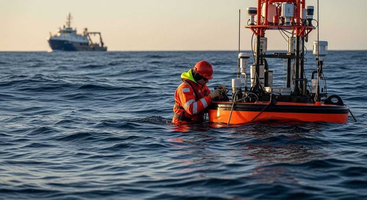
It’s easy to dismiss sensor networks as abstract scientific infrastructure, but their real-world applications are concrete and immediate. NOAA’s ocean monitoring systems collect data on sea surface temperatures, ocean currents, storm surge potential, and salinity levels. That data feeds directly into the models used by the National Weather Service to issue flood warnings, track hurricanes, and predict coastal storm impacts days in advance.
The network includes moored buoys, underwater gliders, tide gauges, and drifting sensors deployed across vast stretches of ocean. Each one acts as a data node, constantly transmitting readings that are woven into forecast models. When one goes dark, there’s a gap. When dozens go dark, the models start to lose accuracy in ways that matter enormously at the local level.
Think about a coastal community in the Carolinas preparing for a hurricane. Emergency managers are making decisions about evacuation orders based on storm surge predictions. Those predictions depend on accurate, real-time ocean data. Remove a significant portion of that data, and the margin for error in those predictions grows – potentially the difference between an evacuation order issued in time and one issued too late. Basically it is likely blinding a surgeon and asking them to operate.
The sensors also play a long-term role in tracking climate trends. Sea surface temperature data collected over decades provides some of the clearest evidence of ocean warming, a phenomenon closely tied to the intensification of hurricanes and the acceleration of sea level rise and as Arctic sea ice reaches record lows, having continuous ocean data has never been more critical.
The political decision behind the data cuts

The cuts to ocean monitoring systems come as part of sweeping budget reductions at NOAA, driven by the administration’s broader agenda of shrinking federal agencies. DOGE-affiliated reviews flagged numerous NOAA programs as redundant or non-essential, and the ocean sensor networks got caught in that sweep.
The logic, at least as presented publicly, is that private sector alternatives can fill some of the gaps. There’s growing commercial interest in ocean data collection, and some tech companies are developing proprietary monitoring systems. But those systems are nowhere near the scale, reliability, or accessibility of the federal network. Commercial ocean data is expensive, often proprietary, and not designed to meet public safety requirements the way NOAA’s infrastructure is.
Critics within the scientific community have been blunt about what this means with retired NOAA scientists, university researchers, and environmental policy experts have pointed out that the United States built this sensor network over decades precisely because private markets don’t naturally invest in public goods like weather prediction and disaster preparedness. Dismantling it to save money in the short term creates far larger costs downstream – in disaster response, property damage, and lives affected by inadequate warnings.
This decision also sits awkwardly alongside other ocean-related policy moves. The administration has already revoked millions of acres of ocean designated for wind power, pulling back from clean energy development offshore. Now it’s also pulling back from the monitoring infrastructure that helps us understand those same waters. It’s a double retreat from ocean stewardship at exactly the wrong time.
Who gets hurt when flood warning data disappears
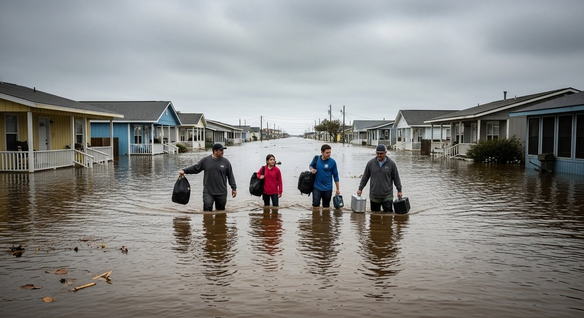
The communities most dependent on accurate flood predictions are the same ones with the fewest resources to recover from disasters. Low-lying coastal areas, many of them home to lower-income residents and communities of color, rely heavily on public warning systems because private options don’t exist for them. Wealthy coastal homeowners have access to private meteorologists and the financial cushion to absorb bad outcomes. Everyone else depends on the public system.
Flood events are already increasing in frequency and severity across the U.S. Gulf Coast, the Eastern Seaboard, and parts of the Pacific Coast and the question isn’t whether floods will happen but whether communities will have enough warning to protect themselves. Degrading the data infrastructure behind those warnings shifts the answer in a dangerous direction.
Beyond immediate safety, there are economic implications that ripple outward. Property insurance markets are already under severe stress in flood-prone states like Florida and Louisiana. Insurance companies rely on sophisticated risk models that depend on historical and real-time climate data – the same data that ocean sensors help provide. Degrade the data, and you degrade the accuracy of risk assessments, destabilizing insurance markets that are already struggling to price coastal risk in a warming world.
Data loss in a warming world is not recoverable

There’s something irreversible about cutting climate and ocean monitoring systems that doesn’t apply to most other policy decisions in that if a future administration decides to restore funding, they can rebuild sensor networks over time. But the data that wasn’t collected during the gap is gone forever. Climate science depends on continuity – long-running datasets are uniquely valuable because they capture trends that reveal how ocean temperatures are changing, how sea levels are rising, and how storm patterns are shifting.
Gaps in that record create real scientific problems. Models that rely on continuous datasets lose predictive power when years of data are missing. Scientists trying to distinguish natural variability from long-term climate trends need unbroken time series to do that work reliably. Breaking the record permanently reduces our ability to understand what’s happening and why.
The administration’s retreat from ocean data is part of a wider erosion of U.S. climate monitoring capacity. It’s worth remembering that the ocean absorbs about 90% of the excess heat trapped by greenhouse gases. Understanding what’s happening in those waters isn’t a luxury, and undermining the data that informs global climate reporting sets back the work of scientists and policymakers worldwide, not just in the U.S.
What comes next for ocean monitoring
Some researchers and state governments are already exploring ways to compensate for federal cuts. Certain coastal states have their own monitoring programs, and academic institutions operate smaller sensor networks tied to research missions. International partners like the European Union and Japan maintain ocean monitoring infrastructure that partially overlaps with U.S. coverage areas.
But none of those alternatives add up to a replacement. The U.S. NOAA network is designed at a scale and with a level of integration that no patchwork of state programs and research buoys can match. Ocean advocates and climate scientists are pushing back hard, calling on Congress to restore funding and challenging the administration’s characterization of these systems as non-essential. How that fight resolves will say a lot about whether the country is serious about protecting coastal communities in the decades ahead.
Frequently asked questions about Trump’s ocean sensor cuts
What are NOAA ocean monitoring sensors and why do they matter?
NOAA operates a large network of buoys, underwater sensors, tide gauges, and drifting instruments across U.S. and international ocean zones. They collect real-time data on:
- Sea surface and subsurface temperatures
- Ocean currents and salinity levels
- Wave heights and storm surge potential
- Long-term climate trend indicators
That data feeds directly into flood forecasting, hurricane tracking, and climate modeling used by federal and local emergency managers.
How will cutting ocean sensors affect flood warnings?
Flood prediction models rely on continuous, accurate ocean data. Removing sensors creates gaps that reduce the precision of storm surge forecasts and hurricane track predictions. Communities that depend on those warnings – especially lower-income coastal populations – have less time to prepare and evacuate safely when forecasts lose accuracy.
Can private companies replace NOAA’s ocean monitoring network?
Not at present. Commercial ocean data services exist, but they are:
- Far smaller in scale than the federal network
- Often proprietary and expensive to access
- Not designed to meet public safety and emergency management standards
Building private infrastructure equivalent to NOAA’s network would take years and significant investment, and there’s little market incentive to make it publicly accessible.
Is climate data collected by ocean sensors used outside the U.S.?
Yes. U.S. ocean monitoring data is shared with international scientific bodies and feeds into global climate models, including those used by the Intergovernmental Panel on Climate Change. Cutting U.S. sensors doesn’t just affect American forecasters – it creates gaps in the global scientific record that researchers worldwide depend on.
What other ocean-related policies has the Trump administration changed?
The administration has taken several steps affecting ocean science and conservation, including revoking offshore wind energy designations, cutting NOAA research budgets, and reducing staffing at agencies responsible for marine environmental monitoring. Together, these changes represent a significant rollback of federal ocean stewardship.
Can removed sensor data ever be recovered?
No. Climate datasets require continuity to be scientifically useful for detecting long-term trends. Data that isn’t collected during a monitoring gap is permanently lost. Even if sensor networks are restored later, the missing years create statistical problems that reduce the reliability of long-term climate analysis.
This article is for informational purposes only.
The post Trump Scraps Ocean Sensors Providing Crucial Data on Climate, Flooding appeared first on Green.org.


